
̽����Ƶ, in conjunction with its vendor partners, sponsors hundreds of events each year, ranging from webcasts and tradeshows to executive roundtables and technology forums.
Government Events and Resources
Events

UAV Mapping at Scale with ideaForge: From Mountain Terrain LiDAR Data Acquisition to Automated Cloud Processing
Hosted By: ideaForge & ̽����Ƶ
Large-scale mapping in mountainous and extreme terrains presents unique challenges. Harsh weather, high altitudes, and rugged landscapes can limit the performance of conventional UAVs and slow down data collection. In conditions like these, automating data capture, processing, and storage becomes essential to maintain accuracy, efficiency, and data integrity.
In this complimentary ideaForge webinar, learn how the Q6 UAV platform, combined with Flyght Cloud, enables end-to-end geospatial intelligence in the most demanding environments.
Views of this on-demand webinar will learn how to:
- Conduct high-precision LiDAR and aerial data capture over mountain terrain
- Leverage automated cloud-based processing, storage, and archiving to reduce turnaround time and ensure data integrity
- Generate actionable maps and insights for mining, forestry, power infrastructure, and government projects
Fill out the form below to view this archived event.
Resources
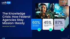
The Knowledge Crisis: How Federal Agencies Stay Mission-Ready
This WalkMe webinar examined how federal agencies are navigating major workforce transitions that put essential institutional knowledge at risk. The session highlighted how WalkMe’s technology helps preserve expertise, streamline operations, and support teams working with limited resources.
Fill out the form below to view this Resource.