
Causeway one.network Solutions for the Public Sector
Built for the way government agencies actually work — map-based, fully auditable, and connected to the navigation tools your residents already use.

Traffic Management
Plan it, coordinate it, communicate it. All in one place.
Traffic Management replaces the spreadsheets, emails, and phone calls with a shared digital workspace where every team member — internal and contractor — can see, plan, and respond to road events in real time. The full process is digital, with a complete audit trail and automatic alerts so nothing falls through the cracks.
- End-to-end digital workflow — every change tracked, every stakeholder automatically notified
- Single map view of all works, closures, and events across your network
- Reduce duplication — no more emailing plans back and forth
- Seamlessly integrates with Live Link for instant navigation app updates
- Publish to Waze, Google Maps, and Apple Maps directly from the plan
- Plan and publish work zones, public events, and incident responses
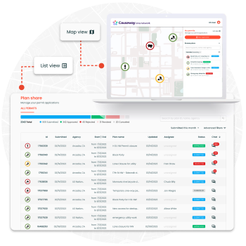
Plan Share
Right-of-way permitting that doesn't make everyone want to quit.
Plan Share digitizes the full right-of-way approval process — from application to approval — on a single, map-based platform. Internal teams and third-party contractors work from the same view, with situational awareness of everything else happening on the network at the same time.
- Submit, review, and approve TMPs and work zone applications in one place
- Map-based view shows exactly how incoming applications interact with existing work
- Self-coordination for contractors before formal application — catch conflicts early
- Full end-to-end solution for both internal teams and external organizations
- Management dashboard with real-time status across all active applications
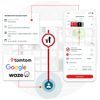
Live Link
The roadside to Waze. In seconds.
Live Link is the mobile app that transforms planned work zone data into real-time, authoritative closure information — published instantly to Waze, Google Maps, Apple Maps, and commercial truck ELDs. Causeway's navigation data partners place a higher level of trust in one.network data, meaning maps update faster and more accurately than standard integrations.
- Close or reopen a road on major GPS services in near real-time — from a phone in the field
- "Worker presence" alerts and temporary speed limits pushed directly to in-vehicle systems
- Higher-trust data partnership means faster, more accurate updates to drivers
- Supports Connected and Automated Vehicle (CAV) communication standards
- Every crew member can contribute to a safer work zone — no technical expertise needed
- Works with Drivewyze, TomTom, and commercial truck ELDs in addition to consumer apps
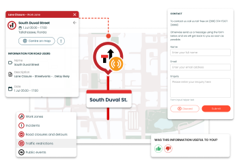
Content Management
Fewer calls. More trust.
Content Management gives the public a clear, accurate picture of what's happening on your roads — without anyone at your agency having to answer another call. Customizable project pages, email alerts, and an embeddable live map let residents stay informed on their own terms.
- Customizable project pages with plain-language descriptions — written for residents, not engineers
- Email alert opt-ins based on resident location or project area
- Embed the live Causeway map directly into your agency's public website
- Social media sharing built in — push updates to your existing channels
- Reporting on public inquiries and sentiment to track what's working
Route Manager
Manage road disruptions and bus route clashes with ease.
Route Manager is a collaborative, map-based tool that connects highway authorities and transit operators to minimize the impact of roadworks on bus routes and critical infrastructure. By enabling proactive disruption management and real-time coordination, agencies can keep transit services running on schedule — even in the face of active roadworks.
- Proactive Clash Management: Identify and resolve potential conflicts between roadworks, bus routes, and underground assets during the planning phase — before disruptions occur.
- Real-Time Coordination: Give ROW teams, transport teams, and bus operators a shared live view of the road network to streamline communication and collaboration across agencies.
- Intelligent Diversion Planning: Detect route conflicts early and plan effective diversions that minimize passenger impact and keep schedules on track.
Network Monitor
Get a real-time view of your entire road network — and respond before disruptions escalate.
Network Monitor gives transportation agencies live, high-level visibility into traffic conditions across their full road network — from highways to secondary roads. With at-a-glance access to key metrics like travel time and average speed, teams can quickly identify abnormal traffic patterns and take action in real time.
- Network-Wide Visibility: Monitor every road in your network simultaneously, with real-time data surfaced in a simple, powerful dashboard.
- Instant Anomaly Detection: Identify areas of abnormal traffic as they develop — so teams can respond before minor issues become major disruptions.
- Key Performance Metrics: Track travel time, average speed, and overall network health from a single interface, giving decision-makers the data they need, when they need it.
Have questions about which solution fits your agency? Talk to a Causeway expert through Ě˝»¨ĘÓƵ.
Contact Ě˝»¨ĘÓƵ